The key element of proposed pipeline or cable construction is a knowledge of anticipated geological conditions. On land, this information can be readily obtained by visual inspection, terrain assessment, geophysical investigations and direct means such as drilling. The acquisition of sufficient geological information is made more difficult in underwater conditions at river, lake and marine crossings.
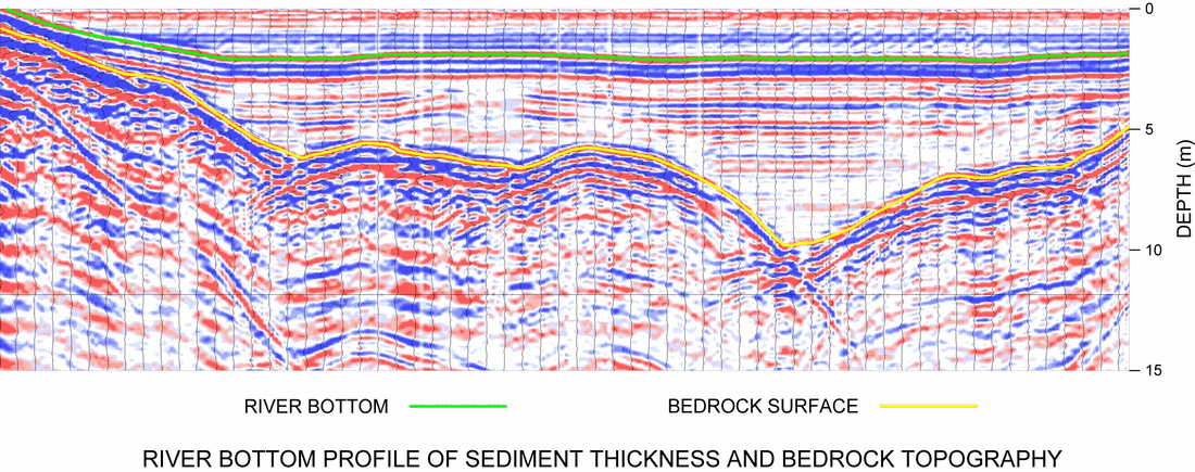
The requirement for more accurate geological information in water covered areas can often be met through the utilisation of high resolution geophysical methods. Geophysical methods are most frequently utilised to determine geological layering, layer thicknesses and composition. Often the primary objective is to map the competent bedrock surface. In addition, geophysical methods are employed to locate bottom and sub-bottom hazards such as cables, drums and miscellaneous debris together with isolated boulders, buried scarps, collapse features, bedrock pinnacles, potentially sensitive layers and unstable slopes. Overwater geophysical methods are also frequently used for inspection of existing pipelines to delineate pipe location, depth of cover and the presence and degree of scouring around the pipe.
A number of geophysical techniques are applicable to overwater investigations including overwater acoustic profiling, side scan sonar, ground penetrating radar, seismic refraction, magnetometer, and electromagnetic methods. Several of these methods can be used over-ice to facilitate access and data acquisition. The majority of overwater surveying however, is conducted from a small survey vessel equipped with several sensors to simultaneously record bottom topography, sub-bottom stratigraphy and accurate survey vessel location information. The recorded data is viewed in real time in order to assess data quality and to identify unusual bottom or sub-bottom features that may require further investigation.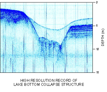
The highest resolution sub-bottom methods are sub-bottom acoustic (seismic) profiling and ground penetrating radar. The acoustic profiling methods employ several frequencies to cover a range of water depths and resolution objectives. With sufficient contrasts in geological layering, these techniques can provide very high resolution images of sub-bottom conditions.